Sponsored

I made a RAN Map

Lil'O Annie

Well-Known Member
First Name
Becky
Joined
Dec 29, 2018
Threads
61
Messages
477
Reaction score
1,364
Location
E. Washington State
Website
www.youtube.com
Vehicles
R1T LE/LG/FE, 2022 Lariat Lightning
Occupation
Farming, semi-retired
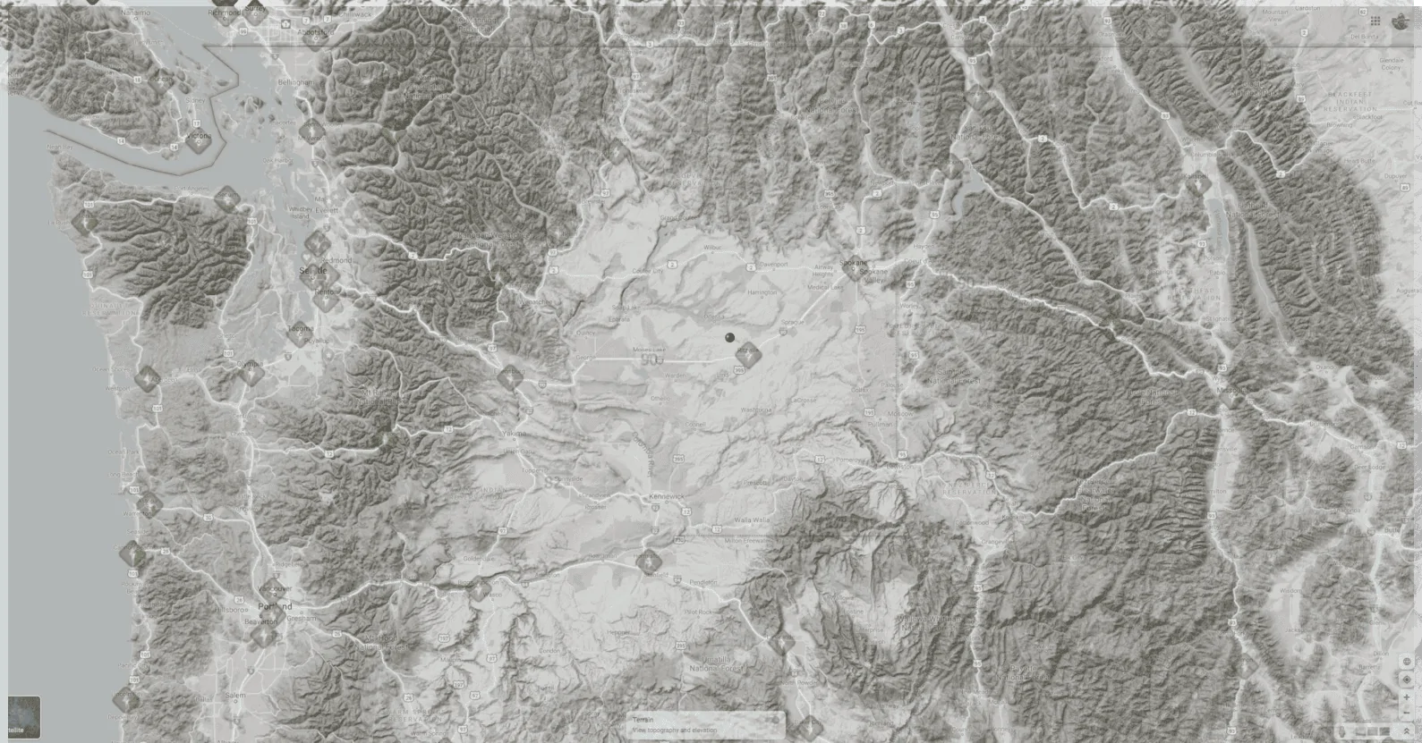
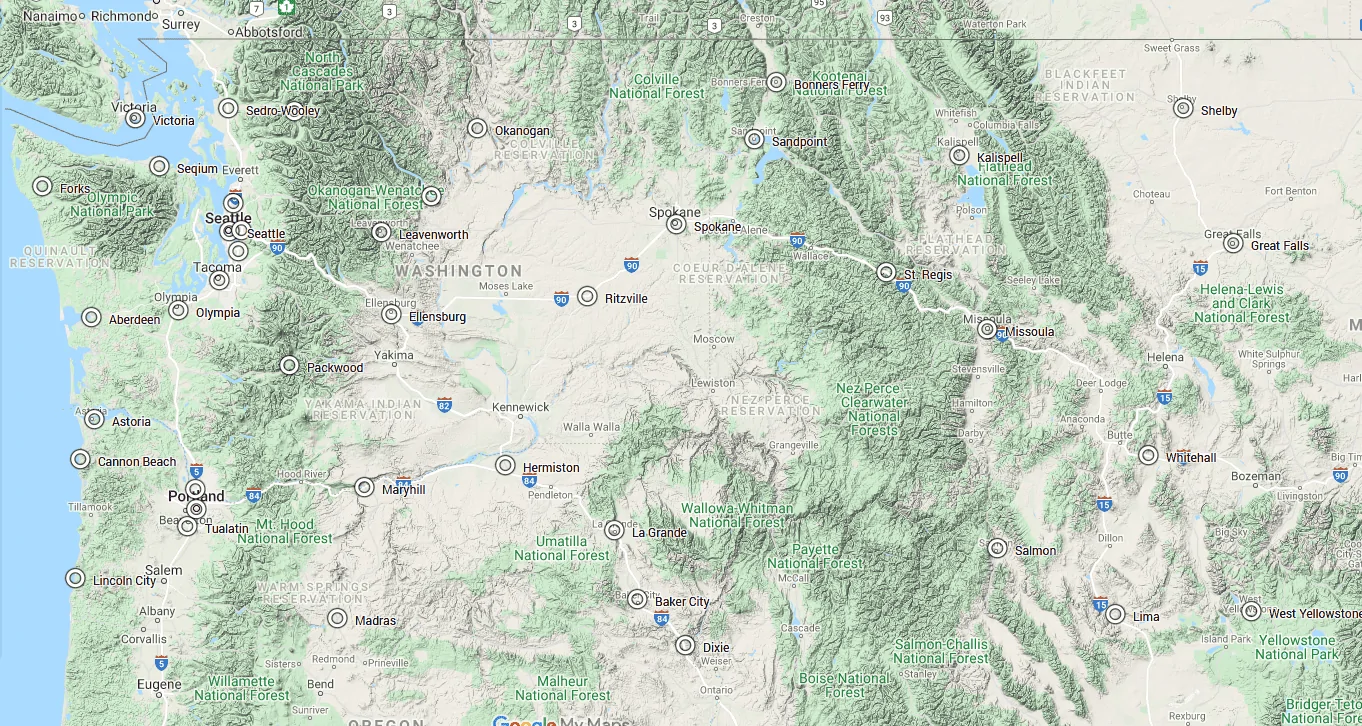
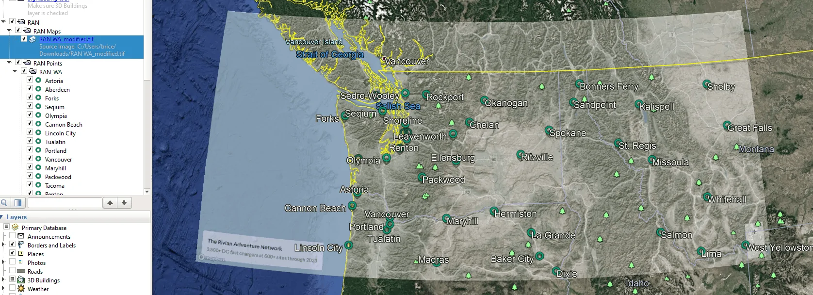
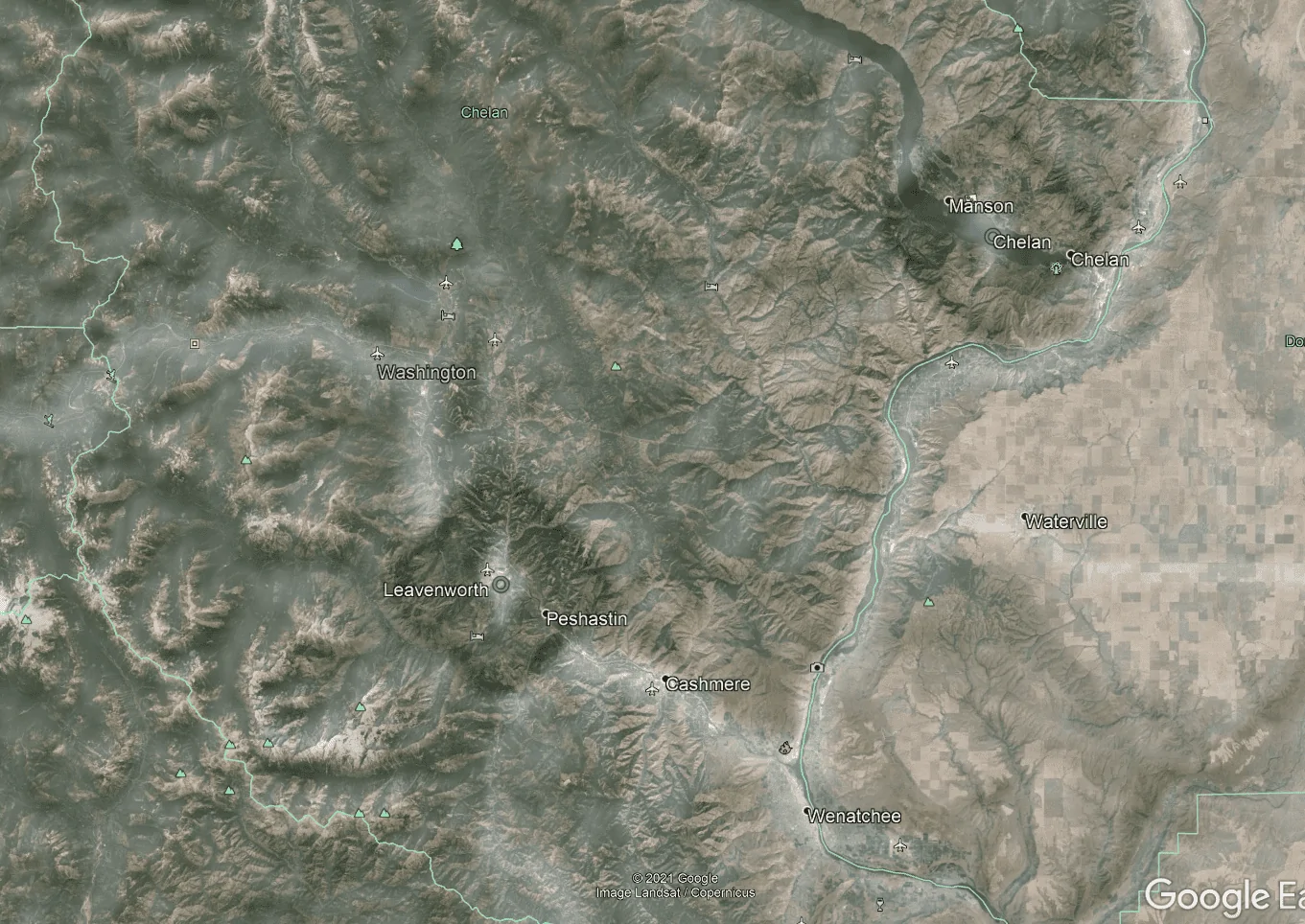
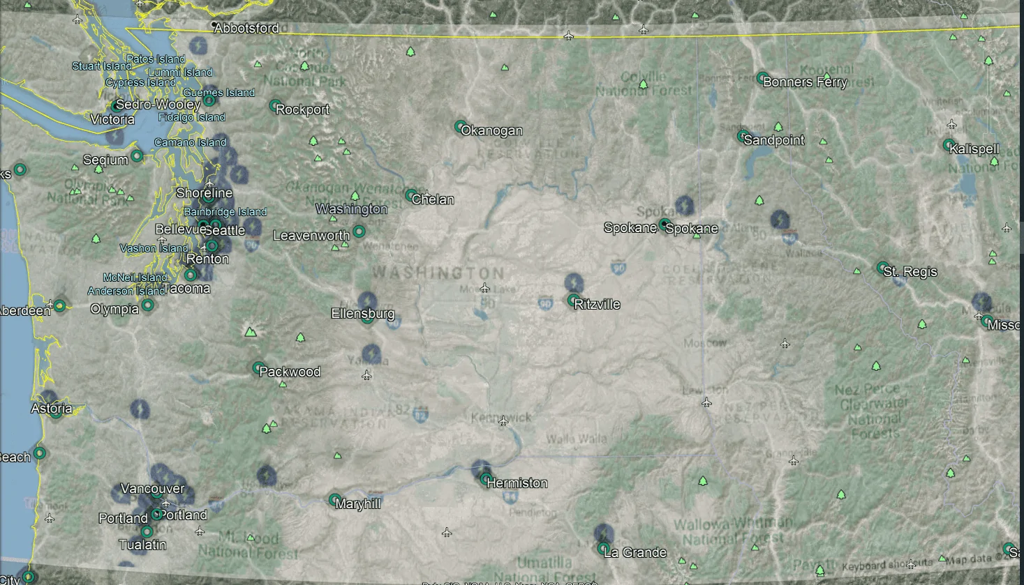
NICE! Here's where we are on the PNW map (red dot). Will have a RAN charger just about 13mi. away from home. :clap:
Rivian R1T R1S I made a RAN Map PNW_RAN_Overlay_Ritzville
Sponsored


Autolycus

Well-Known Member
Joined
May 2, 2021
Threads
14
Messages
2,030
Reaction score
3,116
Location
ATL
Vehicles
ICE only :(
Hey @Bumble1978 or @SeaGeo, did either of you ever attempt to start a GIS map of the RAN? I had a thought about a way to do a basic google map--and share and I think even export that site list. I may play with it this weekend, but might not if someone else has already got decent progress on something.

and of course now we have more specific locations for a number of stations in California, so some of the sites can even be to specific addresses rather than large icons covering entire towns!
 

SeaGeo

Well-Known Member
First Name
Brice
Joined
Jan 12, 2021
Threads
47
Messages
5,237
Reaction score
9,677
Location
Seattle
Vehicles
Xc60 T8
Occupation
Engineer
Hey @Bumble1978 or @SeaGeo, did either of you ever attempt to start a GIS map of the RAN? I had a thought about a way to do a basic google map--and share and I think even export that site list. I may play with it this weekend, but might not if someone else has already got decent progress on something.

and of course now we have more specific locations for a number of stations in California, so some of the sites can even be to specific addresses rather than large icons covering entire towns!
No, I ended up not having time last weekend. It'll be unusually hot in Seattle this weekend, so I may not have a convenient excuse not too. Lol.

In reality it shouldn't take me long, I just need to get QGIS installed on my computer again so I'm not using Arc for private uses.

You could import the image into Google earth easily enough and add a bunch of points to a kml as well. Just a little harder to fit the map to google initially.
 

Temerarius

Well-Known Member
First Name
Chase
Joined
May 26, 2021
Threads
1
Messages
381
Reaction score
1,196
Location
Kirkland, WA
Vehicles
2017 Tesla Model X, 2018 Ram 1500 EcoDiesel
Occupation
Sr. Program Manager
My wife is a GIS Tech as well, I asked her to do this in ArcGIS... she told me to go to hell.

SeaGeo and Little O'Annie are officially my heroes.

It looks like Rivian is not only trying to build out an adventure network (trailheads, beaches, etc...), but also looking to replicate parts of the Super Charger/EA network by dropping pinpoints along the main highways (I-90 and I-5 here in the PNW).
 

SeaGeo

Well-Known Member
First Name
Brice
Joined
Jan 12, 2021
Threads
47
Messages
5,237
Reaction score
9,677
Location
Seattle
Vehicles
Xc60 T8
Occupation
Engineer
Ok, So I've done a test of Washington, north Oregon, Northern Idaho, and Western Montana. The attached zip file has a kml for google earth or maps. I digitized all of the points in described areas as placemarks. The placemarks should be readily viewable (and editable) in google maps if you create your own map, or simply by importing the kml into google earth. An example of all of the points is shown below. You can change the symbols easily in either.
Rivian R1T R1S I made a RAN Map 1624600612443


There is also a folder in the kml titled RAN Maps. It currently won't show the RAN map because of how I referenced the image of the map, but I've included the geogreferenced tif (image file) in the zip. If you use Google earth for desktop you can either change the link in the kml in google earth to point to the tiff on your computer, or just import the tif to google earth. It should come in georeferenced already, and you can play with the transparency easily in google earth. If you pull the image in to Google Earth for desktop it should look like this. Be careful when messing with the transparency, as it's easy to accidentally shift the image overlay.

Rivian R1T R1S I made a RAN Map 1624601385000


Rivian R1T R1S I made a RAN Map 1624601544817


Referencing the images is pretty quick and accurate. I could do that for the entire country in probably an hour or less. However, adding individual points and naming them is a lot more intensive. If people find a lot of value in either of these, particularly the individual points, I can write up a quick tutorial for how to do this. It's pretty straightforward and was done completely with free software.

I was tempted to do the same for electrify america, but there figured this would be a good start.


....and here's a link to the RAN points that I digitized as a map in google. This is the least customizable for people, but may also be the easiest to just check out and play around with.
https://www.google.com/maps/d/u/0/edit?mid=1o0hPTwANzBMs5qM7tZQ5F6rzTSPUbtyf&usp=sharing
 

Attachments

Last edited:

Sponsored

SeaGeo

Well-Known Member
First Name
Brice
Joined
Jan 12, 2021
Threads
47
Messages
5,237
Reaction score
9,677
Location
Seattle
Vehicles
Xc60 T8
Occupation
Engineer
Here's a georeferenced image of the Washington EA Map as well. I didn't digitize the EA Points like I did for RAN, but it's still helpful to have the ferenced image that can easily be added to google earth and play with transparency/zoom in etc. I've attached the georeferenced TIFF as well as a zip due to upload constraints on the forum.
Rivian R1T R1S I made a RAN Map 1624602866420
 

Attachments

KeithPleas

Well-Known Member
First Name
Keith
Joined
Mar 9, 2019
Threads
14
Messages
330
Reaction score
544
Location
Mercer Island
Vehicles
Lexus GX, Porsche Boxster
....and here's a link to the RAN points that I digitized as a map in google. This is the least customizable for people, but may also be the easiest to just check out and play around with.
https://www.google.com/maps/d/u/0/edit?mid=1o0hPTwANzBMs5qM7tZQ5F6rzTSPUbtyf&usp=sharing
Thank you for that! Looking at the routes over the Cascades I was hoping for one in Mazama / Winthrop / Twisp - but the Rockport one before heading over would also be handy and works for either route to get there (we normally stop at Newhalem to use facilities). Leavenworth makes sense for that route. It's the I90 corridor that looks sparse - the downtown Bellevue service center on one end, the other in Ellensburg - both are great for highway access (405, I90) but all the recreation happens in between and I'd like to see one at Snoqualmie Pass.

Overall though I personally am quite fortunate - the Bellevue service center is about 4 miles from me.
 

Autolycus

Well-Known Member
Joined
May 2, 2021
Threads
14
Messages
2,030
Reaction score
3,116
Location
ATL
Vehicles
ICE only :(
@SeaGeo Awesome thoughts. My attempt was going to be a lot more temporary in an important respect. I wasn't going to end up with a geo-referenced image of the RAN map. I was simply going to use an app that allows you to make a window transparent while working with the application that's underneath it. That would allow me to line up a transparent image of the RAN map over Google Maps and start dropping pins into a custom Google Map. Just like your method, the real time sink is in tagging the points. I was going to be pretty lazy with my naming and just name them sequentially by state as I went (GA1, GA2, etc.).

Did you use Google Earth to geo-reference the map? I think I see how to add an image overlay, but my quick effort at fitting my RAN image (a basic jpg screen clip of the RAN map) was giving me more trouble than I hoped. I kept having an odd issue where I could line up several clear locations (state borders and a coastline), but then I would have some other areas that were off by enough to mess things up. And it would be definable characteristics running parallel with each other that would be 2 lined up and 3rd off, so I'm not sure how to address that easily. Maybe I'll have better luck when I'm off the clock and can switch my personal laptop over to the 4k monitor that I'm using for work during the day...
 

SeaGeo

Well-Known Member
First Name
Brice
Joined
Jan 12, 2021
Threads
47
Messages
5,237
Reaction score
9,677
Location
Seattle
Vehicles
Xc60 T8
Occupation
Engineer
@SeaGeo Awesome thoughts. My attempt was going to be a lot more temporary in an important respect. I wasn't going to end up with a geo-referenced image of the RAN map. I was simply going to use an app that allows you to make a window transparent while working with the application that's underneath it. That would allow me to line up a transparent image of the RAN map over Google Maps and start dropping pins into a custom Google Map. Just like your method, the real time sink is in tagging the points. I was going to be pretty lazy with my naming and just name them sequentially by state as I went (GA1, GA2, etc.).

Did you use Google Earth to geo-reference the map? I think I see how to add an image overlay, but my quick effort at fitting my RAN image (a basic jpg screen clip of the RAN map) was giving me more trouble than I hoped. I kept having an odd issue where I could line up several clear locations (state borders and a coastline), but then I would have some other areas that were off by enough to mess things up. And it would be definable characteristics running parallel with each other that would be 2 lined up and 3rd off, so I'm not sure how to address that easily. Maybe I'll have better luck when I'm off the clock and can switch my personal laptop over to the 4k monitor that I'm using for work during the day...
Yeah, I knew what you were going to do. Which is *basically* the same thing I did, but I let the computer do the hard work of stretching and skewing the image. ?

I used QGIS for the georeferencing. Basically what I did it the same thing you did. Identify points on the map, and match them. The benefit of doing it with Q (or other programs not named good earth) is you can associate a bunch of points on your image with a map, and then the program will automatically located and adjust the image, and you can see where you accidentally clicked a point on the map that wasn't quite right because it generates an error in the fit. That avoids the issues your were running into and is honestly a lot faster. It's pretty basic to do anymore, and I can post a writeup for it if people are interested.
 

Sponsored

SeaGeo

Well-Known Member
First Name
Brice
Joined
Jan 12, 2021
Threads
47
Messages
5,237
Reaction score
9,677
Location
Seattle
Vehicles
Xc60 T8
Occupation
Engineer
It's the I90 corridor that looks sparse - the downtown Bellevue service center on one end, the other in Ellensburg - both are great for highway access (405, I90) but all the recreation happens in between and I'd like to see one at Snoqualmie Pass.
Don't forget EA has a north bend spot at the outlets.
 

Autolycus

Well-Known Member
Joined
May 2, 2021
Threads
14
Messages
2,030
Reaction score
3,116
Location
ATL
Vehicles
ICE only :(
Yeah, I knew what you were going to do. Which is *basically* the same thing I did, but I let the computer do the hard work of stretching and skewing the image. ?

I used QGIS for the georeferencing. Basically what I did it the same thing you did. Identify points on the map, and match them. The benefit of doing it with Q (or other programs not named good earth) is you can associate a bunch of points on your image with a map, and then the program will automatically located and adjust the image, and you can see where you accidentally clicked a point on the map that wasn't quite right because it generates an error in the fit. That avoids the issues your were running into and is honestly a lot faster. It's pretty basic to do anymore, and I can post a writeup for it if people are interested.
I did find it MUCH easier to line up the map images when I had tried a while ago with Google Maps vs with Google Earth. I suspect MapBox (I think that's who Rivian is using) uses the same projection as Google Maps. Obviously Google Earth isn't using a projection at all but is using a proper 3D model.

I will take a look at QGIS this afternoon. I long ago got a computer engineering degree but do nothing with that at all for work now, so random projects like this keep me feeling like maybe I didn't completely lose my ability to work problems with a computer. :)
 

SeaGeo

Well-Known Member
First Name
Brice
Joined
Jan 12, 2021
Threads
47
Messages
5,237
Reaction score
9,677
Location
Seattle
Vehicles
Xc60 T8
Occupation
Engineer
I did find it MUCH easier to line up the map images when I had tried a while ago with Google Maps vs with Google Earth. I suspect MapBox (I think that's who Rivian is using) uses the same projection as Google Maps. Obviously Google Earth isn't using a projection at all but is using a proper 3D model.

I will take a look at QGIS this afternoon. I long ago got a computer engineering degree but do nothing with that at all for work now, so random projects like this keep me feeling like maybe I didn't completely lose my ability to work problems with a computer. :)
I'm fairly certain Earth is still working on the same projection system. It's still presenting maps in 2D just like earth. Even though it zooms out to a globe.

Give me a bit and I'll post some Q links to save you some time.
 

Autolycus

Well-Known Member
Joined
May 2, 2021
Threads
14
Messages
2,030
Reaction score
3,116
Location
ATL
Vehicles
ICE only :(
I'm fairly certain Earth is still working on the same projection system. It's still presenting maps in 2D just like earth. Even though it zooms out to a globe.

Give me a bit and I'll post some Q links to save you some time.
Hmm... You're right that Google Earth is still technically using a projection, but its display to the user is a "general vertical perspective projection" vs Google Maps which displays a Web Mercatur projection for its website map tiles. The two display projections definitely cause different stretching and distortions from each other, and it can get really extreme depending on how you place your center and your "view" in Earth.

MapBox does also seem to use the WM projection as their default display. They support custom display projections, but I would be shocked if that RAN map is using one.

As you certainly know better than me, the data that underlies all of the locations in each are all stored as the same non-projected coordinate system.
 

SeaGeo

Well-Known Member
First Name
Brice
Joined
Jan 12, 2021
Threads
47
Messages
5,237
Reaction score
9,677
Location
Seattle
Vehicles
Xc60 T8
Occupation
Engineer
Ok @Autolycus here's the setup.
Grab and install QGIS. It takes awhile to install. Be patient.
https://qgis.org/en/site/forusers/download.html

When you open Q, you'll need to select a basemap. By default it has OpenStreetMap. You can add Google maps and others if you want. The basemaps you're using are under the xyz til, and you'll want to use WGS 84 (lat/long) - it's referred to as EPSG 3857 Pseudo Mercator officially.

If you right click on the xyz tile server you can add more. Here's a quick tutorial.
https://gis.stackexchange.com/questions/20191/adding-basemaps-from-google-or-bing-in-qgis

The Google URLs in ^^ are wrong/outdated. The ones in this link are correct.
https://hatarilabs.com/ih-en/how-to-add-a-google-map-in-qgis-3-tutorial

Grab a screenshot of the RAN map area of interest. If anyone can figure out how to pull out the full map for the US in a higher res from Mapbox, that'd be a lot quicker. For now I just zoomed in as far as I could (basically the PNW) and screenshotted it.

Then georeference the screenshot following this tutorial. It looks longer than it is. If you have any questions, just message me.
https://www.qgistutorials.com/en/docs/3/advanced_georeferencing.html

Once you have the image georeference, it will show up as a layer in the main QGIS window. At that point you can right click it, hit export, and export it as a geoTIFF. You can then import the geoTIFF directly into Google Earth and it (should) place it right where you wanted it so you can create your points.

You can do the points in Q as well. It's just a little more involved than Google Earth.
Sponsored


Top