Sponsored

I made a RAN Map

Bumble1978

Well-Known Member
First Name
Ryan
Joined
Oct 21, 2020
Threads
11
Messages
441
Reaction score
939
Location
Everett, WA
Vehicles
2011 Nissan Leaf, 2009 Toyota Prius
Occupation
IT Manager
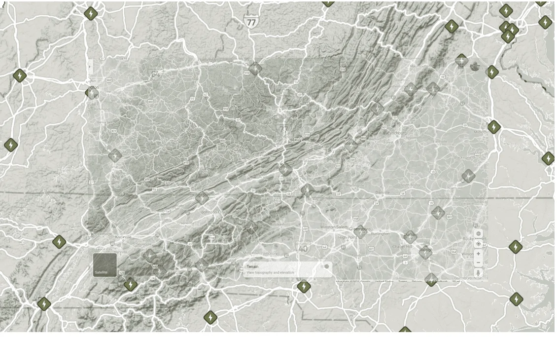
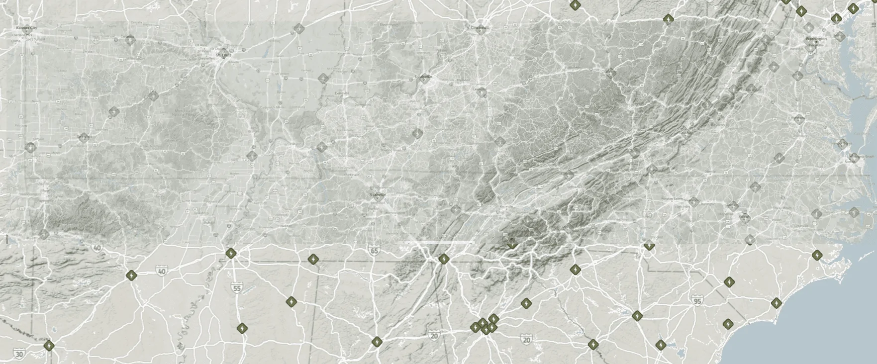
Anyone else want me to make one for your neck of the woods? Or has this already been done somewhere? ? This zoom level shows most smaller/remote city names aligned with the unofficial/approximate locations of the RAN Stations.

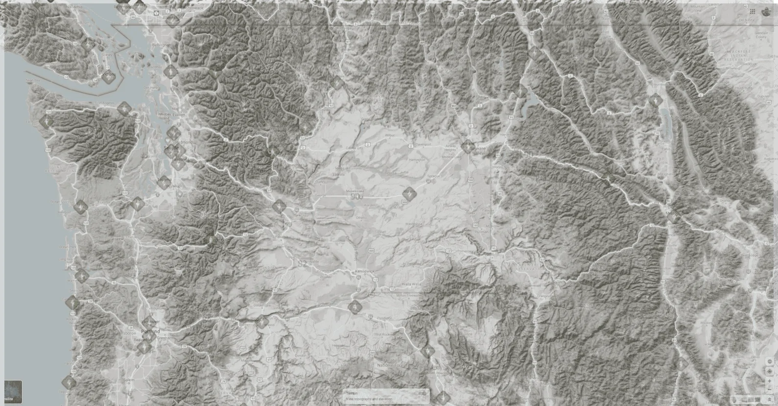
I was quite relieved to discover that there will be about four different RAN's on a few different routes we take to get to our Cabin, closest being ~30 miles away in Okanogan, WA!

Also, ABRP estimates for the 180 pack that we'll arrive at the Cabin with about 20-25% without having to charge which should be about 80 miles of range left. So if we did stop for about 10-15 minutes to charge en route, we'd have plenty to tool around with without having to be concerned about getting back to one.

Rivian R1T R1S I made a RAN Map PNW_RAN_Overlay
Sponsored

 
Last edited:

Autolycus

Well-Known Member
Joined
May 2, 2021
Threads
14
Messages
2,027
Reaction score
3,110
Location
ATL
Vehicles
ICE only :(
I would love to see a solid map of the region around the Blue Ridge Parkway since that was one area they specifically mentioned in their discussion of the RAN. I think they even said it would be built out this year?

I've fiddled with doing the same thing in the area between Atlanta-Charlotte-Nashville, but I would be interested in something showing the whole length of the BRP and Shenandoah. It looks to me like there are 3 locations in Gatlinburg TN, Cherokee, NC, and Robbinsville (?) NC that would make for a good SW corner of the map, and then obviously Shenandoah as the NE corner. I was never able to get enough detail from google maps to cover that whole area though. Maybe you've got a better trick.
 
OP
OP
Bumble1978

Bumble1978

Well-Known Member
First Name
Ryan
Joined
Oct 21, 2020
Threads
11
Messages
441
Reaction score
939
Location
Everett, WA
Vehicles
2011 Nissan Leaf, 2009 Toyota Prius
Occupation
IT Manager
I would love to see a solid map of the region around the Blue Ridge Parkway since that was one area they specifically mentioned in their discussion of the RAN. I think they even said it would be built out this year?

I've fiddled with doing the same thing in the area between Atlanta-Charlotte-Nashville, but I would be interested in something showing the whole length of the BRP and Shenandoah. It looks to me like there are 3 locations in Gatlinburg TN, Cherokee, NC, and Robbinsville (?) NC that would make for a good SW corner of the map, and then obviously Shenandoah as the NE corner. I was never able to get enough detail from google maps to cover that whole area though. Maybe you've got a better trick.
I'll give it a while and see what I can come up with. :)
 
OP
OP
Bumble1978

Bumble1978

Well-Known Member
First Name
Ryan
Joined
Oct 21, 2020
Threads
11
Messages
441
Reaction score
939
Location
Everett, WA
Vehicles
2011 Nissan Leaf, 2009 Toyota Prius
Occupation
IT Manager
How about East Coast?
I quickly realized that like any puzzle starting with a corner makes things much easier, lol ;)

I tried to do Southern Oregon and NorCal next and it was a bit more difficult...

I'll see what I can do. Any particular area you want me to focus on? The Entire coast would need to be done in about 4-5 maps to get that level of detail.
 

Sponsored

martymande

Member
First Name
Marty
Joined
Feb 26, 2021
Threads
1
Messages
21
Reaction score
8
Location
Mount Sinai, NY
Vehicles
R1T
I quickly realized that like any puzzle starting with a corner makes things much easier, lol ;)

I tried to do Southern Oregon and NorCal next and it was a bit more difficult...

I'll see what I can do. Any particular area you want me to focus on? The Entire coast would need to be done in about 4-5 maps to get that level of detail.
Long island going down to south jersey shore, Thanks
 

Autolycus

Well-Known Member
Joined
May 2, 2021
Threads
14
Messages
2,027
Reaction score
3,110
Location
ATL
Vehicles
ICE only :(
I'll give it a while and see what I can come up with. :)
FWIW, the state borders will probably make good reference points. There's a nice corner where NC-TN-GA intersect near Murphy. The other end will probably be easiest to match with a reference along the VA-WV border or maybe if you end up doing 2 maps to cover the region, pulling in the WV-VA-MD intersection.

Thanks in advance!
 

SeaGeo

Well-Known Member
First Name
Brice
Joined
Jan 12, 2021
Threads
47
Messages
5,235
Reaction score
9,676
Location
Seattle
Vehicles
Xc60 T8
Occupation
Engineer
I quickly realized that like any puzzle starting with a corner makes things much easier, lol ;)

I tried to do Southern Oregon and NorCal next and it was a bit more difficult...

I'll see what I can do. Any particular area you want me to focus on? The Entire coast would need to be done in about 4-5 maps to get that level of detail.
Someone could save some time and do the full map in one shot in a GIS program and then either export the a georeferenced image or digitize the locations to share in maps/earth with a KML. That would probably be quicker overall and more useful.
 
OP
OP
Bumble1978

Bumble1978

Well-Known Member
First Name
Ryan
Joined
Oct 21, 2020
Threads
11
Messages
441
Reaction score
939
Location
Everett, WA
Vehicles
2011 Nissan Leaf, 2009 Toyota Prius
Occupation
IT Manager
I would love to see a solid map of the region around the Blue Ridge Parkway since that was one area they specifically mentioned in their discussion of the RAN. I think they even said it would be built out this year?

I've fiddled with doing the same thing in the area between Atlanta-Charlotte-Nashville, but I would be interested in something showing the whole length of the BRP and Shenandoah. It looks to me like there are 3 locations in Gatlinburg TN, Cherokee, NC, and Robbinsville (?) NC that would make for a good SW corner of the map, and then obviously Shenandoah as the NE corner. I was never able to get enough detail from google maps to cover that whole area though. Maybe you've got a better trick.
Here's a quick-n-dirty screenshot....I'm gonna see if I can make the overlay larger...

Rivian R1T R1S I made a RAN Map 1623690910040
 
OP
OP
Bumble1978

Bumble1978

Well-Known Member
First Name
Ryan
Joined
Oct 21, 2020
Threads
11
Messages
441
Reaction score
939
Location
Everett, WA
Vehicles
2011 Nissan Leaf, 2009 Toyota Prius
Occupation
IT Manager
I can go wider, not taller. :)

Rivian R1T R1S I made a RAN Map 1623692540582
 

Sponsored

OP
OP
Bumble1978

Bumble1978

Well-Known Member
First Name
Ryan
Joined
Oct 21, 2020
Threads
11
Messages
441
Reaction score
939
Location
Everett, WA
Vehicles
2011 Nissan Leaf, 2009 Toyota Prius
Occupation
IT Manager
Someone could save some time and do the full map in one shot in a GIS program and then either export the a georeferenced image or digitize the locations to share in maps/earth with a KML. That would probably be quicker overall and more useful.
::Researching GIS and KML::
 

SeaGeo

Well-Known Member
First Name
Brice
Joined
Jan 12, 2021
Threads
47
Messages
5,235
Reaction score
9,676
Location
Seattle
Vehicles
Xc60 T8
Occupation
Engineer
::Researching GIS and KML::
Geospatial software (like Google earth) and a file type. I don't have time to dig into it over the next couple of days, but if someone doesn't give it a go, I may do it this weekend.
 
OP
OP
Bumble1978

Bumble1978

Well-Known Member
First Name
Ryan
Joined
Oct 21, 2020
Threads
11
Messages
441
Reaction score
939
Location
Everett, WA
Vehicles
2011 Nissan Leaf, 2009 Toyota Prius
Occupation
IT Manager
Geospatial software (like Google earth) and a file type. I don't have time to dig into it over the next couple of days, but if someone doesn't give it a go, I may do it this weekend.
Hah, good call, @SeaGeo give it a whirl and see what you can come up with this weekend. I was like XML and a subscription to arcGIS?!?! Does not compute! Eyeballing a couple maps in MS Word though, I'm in. lol ;)
 

SeaGeo

Well-Known Member
First Name
Brice
Joined
Jan 12, 2021
Threads
47
Messages
5,235
Reaction score
9,676
Location
Seattle
Vehicles
Xc60 T8
Occupation
Engineer
Hah, good call, give it a whirl and see what you can come up with this weekend. I was like XML and a subscription to arcGIS?!?! Does not compute! Eyeballing a couple maps in MS Word. I'm in. lol ;)
Yeah. There is some good free opensource stuff out there, but it'd take awhile to pick up how to georeference an image and have the program stretch and skew it as necessary. It's a pretty quick effort for someone who knows what they're doing though.
 

kanundrum

Well-Known Member
Joined
May 2, 2020
Threads
217
Messages
3,976
Reaction score
12,107
Location
Washington, DC
Vehicles
Giulia QV, R1S (S00N)
Occupation
IT
Clubs


Top